April 2017
 We seem to have slipped into an annual routine of doing one long tramp a year with our friends Carole and Marcel. We had booked the Heaphy on an impulse just before we left Christchurch in January and this would be the third Great Walk we had done together.
It is the longest of the nine at just under 80km, but the track is in such a good state of repair that the distance is not a problem. There are no steep ascents, and there is only one of note, a long gradual pull on day one from 100m to 900m, over a distance of 12 km or so. More taxing is the logistics of getting to the start and returning from the finish. We based ourselves in a motel unit at the Top 10 Motueka campsite and enjoy it immensely. Nelson shuttles picked us up from there at 8.30 on Friday morning and dropped us two hours later at the start of the track. The same driver and shuttle picked us up at the end of the track at 12.30 on Monday and took us back to Motueka. We stayed in the same place and had left clean clothes in Marcel’s car. The two shuttles are 100km and then 400km so it is a lot of time on a bus and it is not cheap at aver $200. On reflection, I would fly back and pay the extra $30 or so, if I ever did the track again.
The weather was stunning with warm autumn temperatures six days in a row, clear blue skies and wonderful views. The huts are luxurious with flush toilets, eight beds in a room, solar powered lighting and gas cookers. We were very lucky and enjoyed the trip immensely. We discovered “Hiker’s Wool” before we went and never suffered a blister.
Day 1: Browns Hut to Perry Saddle Hut – 17.5km and 800m of ascent
My pack felt a little heavy with four days worth of food in it. I seem to go over the top on tramps of this length and never really care too much about the weight of the food. So I had three evening boil in the bag meals from Kaweka, three little cartons of milk for porridge and a hefty salami as well. The daily bags of nuts and dried fruit were large too.
The track starts to climb immediately and sets the tone for the day. The gradient is gentle, never more than 10% if that and steady. There are no nasty downs to speak of, the track is superbly maintained and the rivers are bridged if necessary. There was still a hint of cool morning air as we left Brown’s hut and climbed steadily through the forest. This is typical south island bush, with lovely beech forest, silver birch every now and then and a thin ground covering that lets in rays of sunlight all the way to the floor. As we climbed the country opened out for viewing with rows and rows of forested hills.
Marcel pulled a calf within the first two km but did not realise what the injury was for a while. Carole has been doing a lot of walking so it was a novelty to see her maintaining the pace whilst Marcel asked for breaks. Gail bashed on, as quick as ever despite a sore left leg and after four hours we sat down at the shelter at a height of 800m and 12km into the track. Another group of male trampers was there including one partially sighted tramper. There were at least two generations in the group and this was a feature of most groups we met. This seems to be a tramp that Kiwis do as families. We met some groups that spanned three generations, from a 10-year-old boy through his parents to a grandad. There are fewer international tourists on this track too. Mountain biking is allowed but had yet to start when we were on the track.
An hour from the Aorere shelter the track heads downhill to the Perry Saddle and the first hut. It was not until we got there that we realised quite how flash the hut was. It was full with groups going both ways on the track and two dutch tourists just up for the night as they were late in booking and could not get a through tramp.
 The local wekas were inquisitive little birds and seemed to rather like begging for food. A cup of soup, dinner and a warm fire and I was soon ready for a sleep. I crawled into bed somewhere around 8 and was woken later in the night by a lot of snoring. I was attacked by cramp as I tried to climb down for a pee and ended up moving the mattress into the dining room for a quieter second half of the night.
Mt Perry is a one hour climb from the hut. We did not have the energy to climb this but it looks a nice ascent of an hour so to the summit. The track is reportedly very clear even if it is not maintained and quite popular.
Day 2: Perry Saddle Hut to James McKay Hut
We were awake quite early, not surprising as I was asleep by 8.30. My sleep was interrupted by some noisy snorers and I moved out into the kitchen for the rest of the night, waking up all in the room in the process as an attack of cramp hit my right thigh.
The weather continued to be good and was so for the whole of the trip. Temperatures of 20 degrees in the day, cool nights at around 6 degrees. As we set off down through the bush there were hints of a frost in some pockets and low lying mist hid the ground in places. After an hour or so the track emerges from the bush onto the tussock downs. There is a picnic table at a sharp right-hand bend with wonderful views over the national park. The track is visible in the distance as it cuts its way through the tussock, the morning mist was just beginning to be burnt off by the sun and the tops were clear.
 After 7 or 8 km the Gouland Downs hut is reached. This is a small, unmodernised, 8 bunk hut on the edge of a small area of bush. For those doing the track in three days, this seems to be the target for the end of day one. There are camping spots nearby and it must a quiet place compared to the 32 bunk luxury huts used by those taking 4 days. We ate some snacks in the sun and then headed off across the downs.
Day 2 stays between 800m and 900m with a few gentle ascents so the 24km is not as taxing as you might think. Just after the Saxon hut, there is a wonderful little piece of forest, with old stunted and gnarled trees, heavily hung with green moss. This area featured in the films for the Lord of the Rings, an eerie place that just might be home to trolls and other nasties.
Trampers emerge fairly quickly onto open tussock land and head across these on long straight tracks. The rivers, which were very low as we crossed them, are newly bridged to serve the winter mountain bikers. At the far side of the Gouland Downs lies the next hut, Saxon Hut. This is slightly bigger, sleeping 12, but has not been rebuilt and is another more the traditional DoC hut. It provided a nice place for lunch and to top up with water.
The final section is quite a long 12km, with a very steady climb onto a broad ridge that seperates two sections of downs. The way down is then gentle and is a lovely track which weaves through open tussock lland and beautiful forest. There is a bridge halfway along the section and the final km is across a final section of open downland to the James McKay hut, another 32 bunk hut. There was a guided group of 5 in this hut, with the group carrying their own clothes and sleeping bags. Two guides were carrying food for seven across the whole track and they cooked up a 5* meal for them, including wine. No wonder the say the tramp is a gourmet one, and the guides’ packs were very large and very heavy.
 One of the nice things about this track is that most groups stay with you for the whole time, using the same hut. Two families were with us, and their teenage children were great company, very chatty and keen to play cards with us.
Day 3: James McKay hut to the Heaphy Hut
Our third day was shorter at 20km. The first 12km was a steady descent down through west coast bush to the Heaphy river. The contrast between this bush and the ascent was quite marked. This was real west coast territory, with dense rainforest, magnificent trees including one huge rata tree. The temperature was quite cool in the forest and the sun rarely got through the thick green canopy. The birds are wonderful, from the inquisitive robins to the begging wekas.
As you descend there are glimpses of the Heaphy river in the bottom of the valley, a broad river with a rocky granite base, large stones washed up along the sides. At the foot of the descent is the Lewis hut, the first time sandflies made their presence known as we ate lunch in the sunshine.
 From here the track takes you down the true left of the Heaphy river having hopped over a very impressive suspension bridge. This track has its ups and downs as the river meanders through the valley. Right-hand bends force the river hard up on the true left side of the valley and the track is forced up over some bluffs, high enough to feel the strain in your legs after three days. If the rains are heavy this is a very dangerous section: the track floods and the water can be over head height. The Lewis hut has some advice on whether to wait for the river to drop or not.
After 8km from the Lewis hut, the Heaphy hut is reached. A couple of km before this, you can smell the sea and then hear the roar of the surf. The hut is in a stunning situation and is the third luxury hut, with a broad sward of grass in front of it before the beach. The view out across the estuary to the sea is magnificent and tempts you for a walk to the surf. The sandflies are vicious and the water is very cold, but it is worth the trip.
 This is a stunning location, a place of great beauty and visited only by those on the track. It is a privilege to visit this place and it makes you realise how lucky we are to live in such a wonderful country.
Day 4: The Heaphy hut to the Karamea.
Day 4 is perhaps the best of the lot. The Heaphy track is a gentle giant of a walk. It lacks the dramatic alpine scenery of the MIford or Routeburn tracks, but the variety of the four days is wonderful. Day 1 is beech forest, day 2 is open tussock land at a subalpine altitude, whilst day 3 travels through west coast rain forest.
The Heaphy river mouth has a sub climate that is subtropical. Huge ferns grow in abundance and nikau palms form wonderful groves. It felt like home in the Waitakeres.
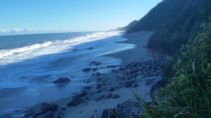
The track follows the coast 16km south, heading towards civilisation. The surf is heavy and pounds the coastline, providing an ever-present soundtrack to the last day. At high tide or in bad weather the waves can cover the track in places. We wandered along in calm weather as the tide receded so could choose to walk on the track or on the beaches. We tended to avoid the beach, as the going is much harder in the sand.
 There is a shelter half way along so you can pause and give the sandflies a feast. After another 3km there is a campsite and then you head up one final climb of 100m or so (in over a km) to a saddle. There is a little track out to a lookout which gives you one final view of the track before the track takes you down and across one final swingbridge and out to the car park.
The shuttle arrived dead on time at 12.30, and we had walked in at 12.20 so it was well timed. We were quickly off, but not soon enough. The sandflies had gained access to the shuttle and feasted on my feet for a while before they were either sated or killed. Five hours later we were back in Motueka ready for a shower, some beer, and a very good steak.
 This was probably the most enjoyable of the great walks that we have done. Our thoughts turned to next year and we were already thinking of Tongariro or the Whanganui as we boarded flights home or set off on a long car journey back to Christchurch.
